الجمعة، 29 يوليو 2011

New Google Search experience for tablets

(Cross-posted on the Inside Search blog)

As part of our effort to evolve the Google design and experience, we’ve improved the www.google.com search experience on tablets. We’ve simplified the layout of search results pages and increased the size of page contents like text, buttons and other touch targets to make it faster and easier to browse and interact with search results in portrait or landscape view.

The search button located below the search box provides quick access to specific types of results like Images, Videos, Places, Shopping and more. Just tap to open the search menu and select an option to see results in one category.


For image results, we focused on improvements that enhance the viewing experience such as enlarged image previews, continuous scroll, and faster loading of image thumbnails.


This improved search experience is rolling out in the coming days to iPad and Android 3.1+ tablets across 36 languages. Give it a try by going to www.google.com in your tablet’s browser.

الخميس، 28 يوليو 2011

Catch the London Underground with Google Maps


Today, Google Maps added public transport directions for London within Google Maps, including Google Maps for mobile on iOS, Blackberry, and Android-powered devices. Now, whether you live in London or are just visiting, you can get public transport directions on your mobile device.


Public transport directions in Google Maps for Android


Google Maps for mobile uses your current location to determine the best trip to your destination. Just search for your destination location, select it on the map and choose the “Directions” option. The suggested trips will be based on your location by default, and provide you multiple alternatives whenever possible.

If you’re using an Android-powered device, you can also get public transport directions with Transit Navigation (Beta) in Google Maps. With this feature, you’ll get alerts when it’s time to get off the bus or train at your destination or to make a transfer. We hope that public transport directions in London make getting around town more convenient!

الأربعاء، 27 يوليو 2011

Google Maps 5.8 for Android adds photo uploads, My Places, and more


Today, Google Maps 5.8 for Android improves Places and Latitude with:
  • Upload photos for a Place
  • My Places as a simple way to manage the Places you’ve starred and recently viewed
  • Descriptive terms for Places in search results
  • Add a new Place on-the-go when checking in
Photo upload for a Place

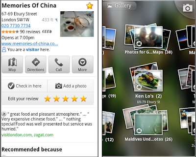
When deciding on a place to go, people often want to know what a place looks like in addition to seeing ratings and reviews. You can now contribute photos to help others get a sense of places. You can now attach your photos to Places, and yours may even become the profile picture for that page. If you want to view or delete any photos you’ve contributed to Places, you can manage uploaded photos in the “Photos for Google Maps” album on your Picasa account.

Left: Uploading pictures to a place. Right: Photos in Android Gallery

My Places and descriptive terms for mobile

In June we announced descriptive terms and ‘My Places’ for the desktop. Both these features are now in Google Maps for mobile. Descriptive terms appear in search results for Places to inform you what businesses are ‘known for,’ such as their ‘eggs benedict’ or being ‘worth the wait.’

Also, My Places for mobile provides quick access to starred and recent Place pages you’ve looked at. You can access My Places by pressing your phone’s menu button while in Google Maps.

Descriptive terms and My Places in Google Maps for mobile

Add a new Place ‘on-the-go’ for check-ins

If you’re out and about and want to check in, we want to make sure you can quickly add a new Place to check into if one isn’t available. This might happen for new businesses or those that haven’t set up a Place page yet. For example, let’s say you’re at Xoogle Xtreme Sports, a new sports shop in your neighborhood. You go to check in but don’t see Xoogle in the list of places to check into and when you do a search still nothing comes up.

Add a Place when checking in, if needed

To solve this, you’ll now see an “Add place” option at the bottom of suggested places. Select that option, and you’ll be prompted to confirm the name and location of the new place. Then a brand new place is added (and you’re checked in). This place will be available for you and others to check into from Latitude, but will not appear as a search result in Google Maps or Google Places.

We’ve also added ‘Bigger text’ to our experimental Labs features and ‘Download map area’ has been renamed ‘Pre-cache map area.’

To start using Google Maps 5.8 for Android, download the update here. This update requires an Android OS 2.1+ device and can be used anywhere Google Maps is currently available. Learn more in our help center.

الثلاثاء، 26 يوليو 2011

Find nearby deals with Google Shopper 1.5 for iPhone

(Cross-posted on the Google Commerce Blog)

We’ve recently made a few new changes to Google Shopper for iPhone that makes it easy to find nearby deals when you’re on-the-go.

In the latest version of Google Shopper, in addition to the ‘Shop’ tab, you’ll now see two new tabs at the bottom of the app: Offers and My Offers. The Offers tab displays a list, or map view, of nearby offers which businesses have submitted through Google Places - from restaurant and movie theater deals to discounts on tennis lessons or a round of golf.

Let's say you come across an offer for free dessert at a nearby restaurant, but you won't have time to use it until the weekend. You can save the offer for future use, then later view and redeem it from the My Offers tab.

Additionally, if Google Offers are available in your city, you’ll be able to view and redeem your purchased offers on the My Offers tab. Google Offers are currently available in Portland, Oregon, the San Francisco Bay Area and New York, with other cities to follow.


Google Shopper 1.5 is currently available for iPhone users in the US and UK with iOS 4.0 and higher. If you’re a current Google Shopper user, you’ll automatically receive an update. Download Google Shopper 1.5 by visiting the App Store. To download Google Shopper for Android, visit Android Market.

الخميس، 21 يوليو 2011

Nexus S Comes to AT&T

Since launching Nexus S with Samsung, T-Mobile and Sprint customers have enjoyed the pure Google experience, running the latest Android releases and Google mobile apps. Today we’re excited to announce a Nexus S device optimized for AT&T, available in Best Buy stores this weekend.

Nexus S runs Android 2.3 and features a 4” Super AMOLED screen, a 1 GHz processor for showing 3D graphics, front and rear facing cameras and support for NFC. It also features the latest Google mobile apps, including Google Earth, Google Maps with Navigation, Google Talk with video chat, Google Voice and Voice Actions, as well as access to more than 250,000 apps in Android Market.

Nexus S for AT&T will be available in Best Buy stores starting July 24. For those of you who just can’t wait, it’s on pre-sale today in Best Buy stores.

You can find more information at google.com/nexus or follow @googlenexus on Twitter for the latest Nexus S updates. And if you need something to pass the time until you can get your hands on one, try our Nexus Contraptions game, where you can bubble, bounce, and bump apps into the phone.


Updated 1:09pm 7/21/2011: Pre-sales are currently only available in Best Buy stores, not on www.bestbuy.com. 

Posted by Hiroshi Lockheimer, Director of Engineering

الثلاثاء، 19 يوليو 2011

3D buildings in Google Maps for Android arise in London, Paris, Barcelona, and more


Last December, the release of Google Maps 5.0 for Android ushered in the next-generation of mobile maps where you can rotate, tilt, and zoom in and out of 3D maps. Whether you’re on the go or playing with a new phone, seeing a 3D skyline spring up in New York City, Zurich, Milan, and other cities is a helpful, fun, and unique experience--an experience we want as many of you as we can to have for your city.

We've been adding more cities and you will now find that 3D buildings are available in London, Paris, Barcelona, Stockholm, Singapore, Lisbon, Boulder, and 11 major cities in South Africa.

3D buildings in London and Barcelona

You don’t need to update the app, just open Google Maps for mobile on your phone with Android 2.0+ and zoom in to a city with 3D buildings. Enjoy!

الأربعاء، 13 يوليو 2011

Live traffic information for 13 European countries


Today Google Maps added live traffic coverage for 13 European countries: Austria, Belgium, Czech Republic, Denmark, Germany, Ireland, Israel, Luxembourg, Netherlands, Poland, Slovakia, Spain and Switzerland. The new traffic information will automatically be available in Google Maps for Android, iOS, and mobile browsers.

Left: Traffic layer in Munich
Right: Getting routed around traffic in Google Maps Navigation

With the addition of live traffic data, users in these countries will now also be able to be routed around traffic in Google Maps Navigation (Beta) to save precious minutes when possible.

الثلاثاء، 12 يوليو 2011

Finding great deals is easier with Google Shopper 2.0

Today we’re announcing a new set of features in Google Shopper for Android to make it even easier to research products and find great value deals when you’re on-the-go.

First, we’ve moved features around a bit to help you perform common tasks more quickly. For example, the ‘Starred’ and ‘History’ buttons are now at the top of the page. We’ve also added new tabs to the bottom of the screen for fast navigation to Google Shopper’s newest features.

With Google Shopper, you can now find, save and redeem offers at nearby businesses through three tabs:
  • Today’s Offer: part of the Google Offers beta program, this tab displays a single offer for discounted goods or services in your area. Today's Offer is currently available in Portland, Oregon, the San Francisco Bay Area and New York, with other cities to follow.
  • Nearby Offers: when you click this tab, you'll see offers in the 'Eat' and 'Play' categories which nearby businesses have submitted through Google Places.
  • My Offers: for those of us who occasionally misplace coupons or gloss over expiration dates, Google Shopper makes it easy to stay organized. When you come across an offer you like you can save it for later. Your saved and purchased offers appear on this tab and you can see which offers are close to expiring. To take advantage of an offer, just navigate to ‘My Offers,’ select the one you’d like, and click ‘Redeem’. In the future you’ll also be able to access and redeem your saved offers using Google Wallet.

Tap on Today’s Offer, Nearby Offers or My Offers to see great deals.


Visit Android Market to download Google Shopper 2.0, currently available for Android 2.1 and higher devices in the US and UK. If you already have the app installed you’ll automatically receive a notification to update it.

الخميس، 7 يوليو 2011

Share your docs on the go with the improved Google Docs for mobile

(Cross-posted from the Google Docs blog)

Google Docs is about collaboration, but as many of us know, others often rely on us even when we’re nowhere near a computer. That’s why we’re excited to bring the features you need to your tablet and mobile device’s browser. Today, we've updated the look of Google Docs for mobile browsers and added the ability to sort, narrow, and share multiple docs in your mobile docs list.

To get started, go to docs.google.com from your supported device’s browser. Press Sort to organize the list of docs visible in the mobile browser, or press Narrow by to specify the subset of docs you’d like to see.


To share from your mobile docs list, select one or more documents, press the Share button, and select Share, Get the link to share for public or unlisted docs, or Email as attachment. Sharing a doc in your mobile browser works the same way as it does on the desktop.


We’re committed to improving the experience of accessing your docs from your mobile device. We’d love to hear what you think is working and what isn’t in our support forums as well as in the comments of this post.

“Download map area” added to Labs in Google Maps for Android

(Cross-posted on the Official Google Blog)

One way we bring you new product features is through Google Labs—a collection of fun, experimental features you can turn on if you’re interested in the functionality. In fact, Google Maps itself started as a lab. In addition to our desktop Maps Labs, Google Maps for Android has a few tricks you can try out right from your phone. We’d like to introduce you to one new experimental feature, “Download map area," but also remind you of two other ones we already have: “Scale bar” and “Measure.”

Download map area
When you’re visiting an unfamiliar location, Google Maps for mobile is great for getting an idea of how close you are to your destination, where streets and landmarks are in relation to each other, or just for getting “un-lost.” But what if you don’t have a data signal, or you’re abroad and don’t have a data plan? We say that if you use Google Maps for mobile, you’ll never need to carry a paper map again. The “Download map area” lab in Google Maps 5.7 for Android is a step in making that statement true even when you’re offline.

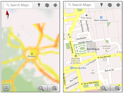
Let’s say later you’re visiting Bordeaux during a trip to France. If you were to open Google Maps for mobile and zoom into Bordeaux without data coverage or wifi, you’d see the image on the left:

Left: Bordeaux with no data or wifi. Right: Bordeaux with downloaded map area

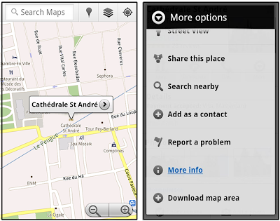
That’s not particularly useful when you’re trying to find out how close you are to the Cathedrale St. Andre. But a little advance planning and “Download map area” can help. Before you take your trip, while you still have access to WiFi or data coverage, you can open up any Places page in the world, click “More” to get the Place page menu, and download Google’s maps for a 10-mile radius.

Left: Tap a landmark to enter its Place page Right: Place page “more options” menu

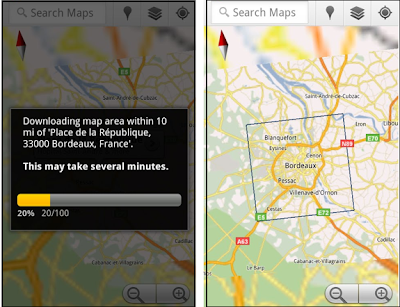
The download can take as little as a minute or two. This download stores only the base map tiles and the landmarks on the map, so you still need a data connection to see satellite view and 3D buildings, search for Places and get directions. But we hope the level of detail available will help you find your way!

Left: Status screen for download. Right: Coverage of downloaded map area

All your downloaded map areas can be managed in your Google Maps cache settings so you can delete maps you no longer need or if you want to free up storage. After 30 days, all downloaded map areas will be removed from your cache; they can be re-downloaded any time.

Scale bar
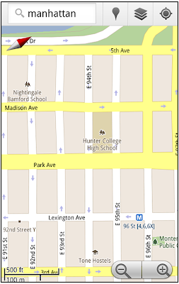
Google Maps has approximately 20 different zoom levels that range from a 2,000 mile scale to a 20 foot scale. With finger gestures making it really quick and easy to zoom in and out, sometimes it’s not always clear what zoom level you’re at. What might be just a few streets away can be quite a long walk depending on the scale. To help with this, you can turn on a scale bar, which updates based on your zoom level.

Scale bar in the lower left

Measure
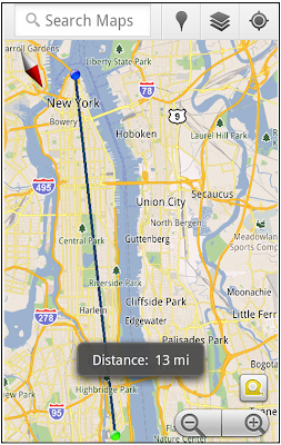
If you ever need to know the distance between San Francisco and New York (about 2602 miles) or between any other two points on the map, the “Measure” lab can help you out. Once it’s enabled, you’ll notice a tape measure icon just above the zoom buttons. After clicking that icon, you’ll be prompted to tap two points on the map and Google Maps will calculate the straight distance between those points (this direct distance is “as the crow flies”).

Example of the “Measure” Labs feature

To access Labs on your phone, press your phone’s menu button once in Google Maps, choose “More” and select Labs. On a tablet, click the menu button in the upper-right corner of Maps. The “Download map area” lab requires Android 2.1+ and the latest version of Google Maps. We look forward to bringing you more experimental features soon and hope you enjoy trying out Labs in Google Maps for Android.

الأربعاء، 6 يوليو 2011

Google Maps 5.7 for Android introduces Transit Navigation (Beta) and more


(Cross-posted on the Official Google Blog)

Today we’re releasing Google Maps 5.7 for Android. From Bangkok to Baltimore, we’ve added Transit Navigation (Beta), updated access to directions, better suggested search results, and a photo viewer to Place pages—all of which can help you whether you’re traveling to an unfamiliar part of town or visiting a city across the world.

Transit Navigation (Beta)
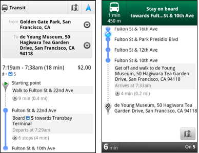
Google Maps Navigation (Beta) currently provides over 12 billion miles of GPS-guided driving and walking directions per year. Now, GPS turn-by-turn (or in this case, stop-by-stop) navigation is available for public transit directions in 400+ cities around the globe with Transit Navigation.


Transit Navigation uses GPS to determine your current location along your route and alerts you when it’s time to get off or make a transfer. This is particularly helpful if you’re in a city where you don’t speak the language and can’t read the route maps or understand the announcements. After starting your trip with Transit Navigation, you can open another application or put your phone away entirely and Google Maps will still display an alert in your notification bar and vibrate your phone when your stop is coming up.

Left: Transit directions without Navigation. Right: with Navigation


Navigation alerts appear even if you switch to another app

Now you can spend more time enjoying the sights out the window and less time worrying about how many stops are left, where you are along the route or whether you missed your stop. Since Transit Navigation relies on GPS signals, we recommend using this feature for above-ground transit.

Updated Directions
Now that we’ve improved our directions services, we wanted them to be incredibly easy to pull up on your screen. If you select the driving or walking icon and your route is supported by Google Maps Navigation, the Navigation icon will automatically appear so you can get access to step-by-step directions in one click. Note: this change is currently only in place for driving and walking and does not appear for public transit.

One-click access to Navigation from directions

We’ve also streamlined how you access directions from within a Place page. Before, clicking directions in a Place page would bring up options for “Driving Navigation,” “Walking Navigation” and “Directions.” Now, you’ll be taken straight to the map and see the new directions box shown above.

Improved Search Suggest
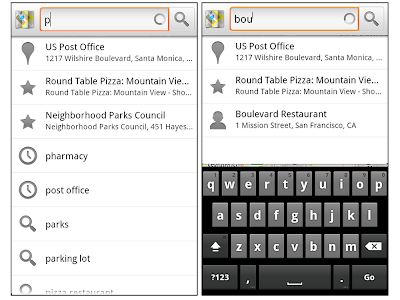
We’ve made two changes to search suggestions that improve their quality and speed. First, we’ve added category icons, so instead of all search suggestions displaying the same icon, the icon next to the listing will reflect the type of result. You’ll see a pin for a Google Places listing, a star for a starred Place or location, a clock for a previously used search term, a person for contacts and a magnifying glass for “anything else.”

Two examples of search suggest with new icons

Also, any place you got directions to or called directly from its Places page will be included as a suggestion for a relevant search. For example, if you recently received directions to the U.S. Post Office on Wilshire Boulevard, afterward, when you begin a search with [p] or [bou], that U.S. Post Office would appear as a search suggestion.

Photo viewer for Place pages
Since we released business photos for Place pages last October, millions of photos have been added to Place pages around the world. To enable you to view these photos on the run, a slick new photo viewer has been added so you can browse photos while deciding where to go.

Left: Business photos in Place pages. Right: New photo viewer

To start using Google Maps 5.7 for Android, download the update here. This update requires an Android OS 2.1+ device and works anywhere Google Maps is currently available. Learn more at our help center and have fun exploring, whether it be by car, transit, bike or foot.